Geographic Information Systems enable users to visualize, analyze, and interpret data linked to specific locations. They are fundamental in resource management, urban planning, and environmental monitoring, offering technological insights into spatial relationships and patterns.
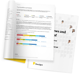
The top 5 Geographic Information System solutions are ESRI ArcGIS, Mapbox, LightBox Vision, CartoDB and SiteRecon, as ranked by PeerSpot users in June 2026. ESRI ArcGIS received the highest rating of 9.0 among the leaders, is the most popular solution in terms of searches by peers, and holds the largest mind share of 17.2%.
Geographic Information Systems allow experts to integrate various data layers, facilitating spatial analysis and data visualization on maps. These systems aggregate data from satellites, GPS, and other sources, enabling stakeholders to make data-driven decisions. Professionals use Geographic Information Systems to interpret complex datasets, aiding in tasks such as risk management, logistic planning, and trend identification. The ability to analyze spatial data through Geographic Information Systems offers unmatched precision and insights into geographical patterns.
What features set Geographic Information Systems apart?In urban planning, Geographic Information Systems support the design of sustainable cities by evaluating land use and infrastructure. In agriculture, they optimize crop management and monitor land health. In public health, they trace disease patterns and allocate resources efficiently.
Geographic Information Systems help organizations streamline processes and improve resource allocation by analyzing location-based data. They support strategic initiatives by providing geographical insights that bolster data-driven approaches across multiple sectors.
| Product | Mindshare (%) |
|---|---|
| ESRI ArcGIS | 17.2% |
| Mapbox | 15.7% |
| LightBox Vision | 12.3% |
| Other | 54.8% |


Geographic Information Systems offer powerful tools for urban planners to analyze spatial data and make informed decisions. You can use GIS to visualize current infrastructure, assess land use patterns, and predict the impact of future developments. By integrating GIS into urban planning, you enhance your ability to design efficient transportation systems, manage natural resources, and improve public services. The ability to overlay different data sets also helps identify trends and challenges within urban areas, providing a comprehensive approach to sustainable city development.
What is the role of GIS in disaster management?GIS plays a crucial role in disaster management by providing tools to map and analyze natural hazards. With GIS, you can predict the impact of disasters, plan evacuation routes, and allocate resources effectively. During emergencies, GIS allows responders to visualize the extent of impact in real-time, facilitating efficient coordination. You can also use GIS for post-disaster analysis to improve future resilience and recovery efforts, ensuring communities are better prepared for similar events in the future.
How does GIS technology benefit environmental conservation?GIS technology is invaluable for environmental conservation. You can use GIS to monitor ecosystems, track wildlife movements, and assess changes in land use. It allows you to analyze spatial data to understand environmental patterns and processes. By utilizing GIS, you can make data-driven decisions for managing protected areas, restoring habitats, and implementing conservation strategies. GIS also aids in visualizing human impacts on the environment, providing a clear basis for advocacy and policy-making.
What are the benefits of using GIS in agriculture?GIS technology in agriculture enhances precision farming practices, leading to increased efficiency and productivity. You can apply GIS to analyze soil conditions, crop health, and weather patterns. This enables you to make informed decisions about crop rotation, irrigation, and fertilization. With GIS, you can also monitor agricultural land use changes and optimize resource allocation. By enhancing your understanding of field variability, GIS supports sustainable farming practices and helps maximize yields.
How can businesses leverage GIS for market analysis?Businesses can leverage GIS for market analysis by integrating spatial data with demographic, economic, and consumer behavior information. GIS enables you to visualize and interpret complex data, identify market trends, and target specific geographic areas for expansion. By analyzing spatial patterns, you can optimize location-based strategies, enhance logistics operations, and improve customer service. GIS also allows you to assess competition and identify untapped markets, providing a strategic advantage in your industry.